
Fort Sill And Other Military Sites Hidden On Apple Maps But Visible On Google
A new day, a different rabbit hole. I saw a blurb on Facebook about how Apple Maps is now censoring military installations across the USA, and I can't help but think, why?
I'm sure there's some super-secret something or other coming down the pipe, a request, maybe with a little emphasis from the high brass in DC, but if every other infinitely more reliable mapping site out there is still giving our military installations the Full Monte treatment, what's up with Apple?
Full disclosure, I had to check on the Apple Maps website because I refuse to accept the limitations of old people phones... But the rumor checked out.
Why Is Apple Maps Blurring Fort Sill?
From Apple Maps:
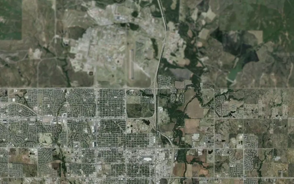
You can clearly see Lawton if you're familiar with what you're looking at, and yep, Fort Sill is clearly blurred.
Apple Maps vs. Google Maps: The Satellite View Difference
As opposed to Google Maps, which clearly labels everything so even the most unfamiliar lurker could identify everything...
From Google Maps:

Curious, right?
I think most people would at least understand why a military installation would prefer to be secretive, if not a little suspicious of it anyway... But if you can get a clear view literally anywhere else, why the secrecy from Apple in the first place?
Like most shenanigans, this will probably end up the topic of many heated debates between those who accept government privacy and those who go straight to conspiracy theories. Not that there's anything wrong with that.
You can almost see it now. Spy cameras along our roads all across the country, but don't be looking at the government...
Then again, and you know I hate to give the government the benefit of the doubt, but they haven't censored Area 51 yet...

So maybe this is just Apple trying to set themselves apart without actually improving the performance of their product. I mean, it keeps working for them on the iPhone platform, stuck a few years behind everyone else, so why not try it with the maps too?
Not an opinion. That's a fact at this point.
What do you think is going on here?
The Weirdest & Craziest Things Found in Texas on Google Maps
Gallery Credit: Daniel Paulus
LOOK! You or Someone You Know Might Be Visible on Google Street View!
Gallery Credit: JB Love
Want to Know Where They've Been Going? Try this Easy iPhone Hack!
Gallery Credit: TSM/Bristol
More From KZCD-FM